
Fast Rust core
Tile fetching, GeoTIFF reading, rasterizing and patch encoding run in Rust. One wheel per
platform covers Python 3.10 and newer. pip install and go.

pip install mapcv
Three commands
Answer four questions, or start from a template.
$ mapcv init
1/4 Imagery
Imagery [esri/sentinel2/custom] (esri):
2/4 Area
Area: 4.9375,52.3725,4.9515,52.3780
Zoom (17): 18
3/4 Labels
Label file: buildings.geojson
Which field holds the class? (): class
4/4 Patches and output …
✓ Wrote mapcv.yaml
See tiles, patches, disk and memory before downloading anything.
$ mapcv plan mapcv.yaml
╭─ Plan for mapcv.yaml ─────────
Imagery  esri_satellite · zoom 18
         (≈ 0.36 m/px)
Raster   2,816 × 1,792 px · 77 tiles
Labels   967 polygons
         classes: building → 1
Patches  ≈ 77 × 256 px
Output   dataset · png (≈ 8.6 MB)
Fetch, rasterize, cut patches and split, with a summary at the end.
$ mapcv generate mapcv.yaml
Reading imagery and writing patches
━━━━━━━━━━━━━━━━━━━━ 2/2 chunks
╭─ Dataset ready ───────────────
Patches  77
Shape    256×256×3 uint8
Splits   train 52 · val 8 · test 17
Time     21s
  building   1   19.0%
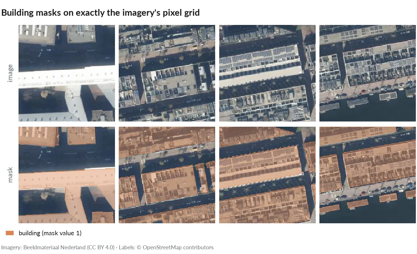
Real (trimmed) output from the Quickstart: 967 OpenStreetMap building outlines in Amsterdam, imagery at about 0.36 m per pixel, 77 labeled patches in under half a minute. Figure: patches and masks over the same area (imagery: Beeldmateriaal Nederland, CC BY 4.0; labels: © OpenStreetMap contributors).
Why mapcv
Fast Rust core
Tile fetching, GeoTIFF reading, rasterizing and patch encoding run in Rust. One wheel per
platform covers Python 3.10 and newer. pip install and go.
Leakage-safe splits
The default spatial split keeps whole blocks of the map in one split and drops train/val
patches that overlap a test patch, so scores aren’t inflated by shared pixels.
Any imagery, six tasks
XYZ tiles, your own GeoTIFF/COG, Sentinel-2 (EOPF or STAC with cloud masking) or Earth Engine, into segmentation, detection, instance, classification, change or regression data.
Large regions, resumable
mapcv plan estimates tiles, disk and memory first. Generation runs in bounded windows and
picks up where it stopped, byte for byte the same as an uninterrupted run.
ML-ready output
Patches as PNG, JPEG, NPY or georeferenced GeoTIFF, COCO/YOLO, a manifest and split lists.
Load them with MapcvDataset, or export to Hugging Face, WebDataset, Zarr and TerraTorch.
Keys stay private
API keys in a tile URL never reach the manifest, logs or messages, and Earth Engine runs on your own login. Each source’s credit line is listed and written into the dataset card.
What you get
See Dataset format for every field.
How it compares
mapcv does one job: it writes a static, reproducible dataset from imagery and labels, checked against reference implementations. On the benchmarks, a careful rasterio script, GDAL’s tools and leafmap produce the same patches, 1.5–34× more slowly.
More in Why mapcv.
The tools combine well: a mapcv dataset is plain files, so you can train it with any library.
Next